Wednesday, April 7, 2010

The People's Republic of Bangladesh

About Bangladesh


The People's Republic of Bangladesh
Bangladesh emerged as an independent and
sovereigncountry in 1971 following a nine-month
war of liberation. It is one of the largest deltas in
the world with a total area of 147,570 sq. km. With
a unique communal harmony, Bangladesh has a
population of about 140 million, making it one of
the densely populated countries of the world.The
majority(about 88%) oare Muslim. Over 98% of the
people speak in Bangla. f the people English
however, is widely spoken. The country is covered
with a network of rivers and canals forming a
maze of interconnecting channels. Being an active
partner, Bangladesh plays vital role in the international
and regional forum, particularly in the UN,

Commonwealth and South Asian Association of

Bangladesh
Regional Cooperation (SAARC).

Area
59.977 sq.miles or 1,47,570 sq. km . Territorial water 12
nautical miles in the high seas measured from the base
line.


Capital City
Dhaka, Metropolitan Area 1528 sq. km. Dhaka, the capital
of Bangladesh is situated almost in the middle of the
country on the bank of the river Buriganga. This historic
city was founded in 1608 A.D. by the Muslim
MughalEmperors and has a rich history of more than
2000 years. The city has all modern facilities with
Dhaka City
international hotels equipped with all modern
communication systems. The places of historical interest
in the city are National Museum, Lalbagh Fort, Baldha
Garden, Ahsan Manzil (Palace), Bara Katra, Chhoto Katra,
Zoo etc. Besides, the National Martyr’s Memorial at Savar
and the Folk Museum at Sonargaon are two attractive
places within reasonable distance.

National Parliament
Official Country Name

"The People's Republic of Bangladesh"


Governmen
The country has a Parliamentary Form of Government
headed by the Prime' Minister. The President is the
constitutional head of the State.

Climate
Standard Time
GMT + 6 Hours

Name of Currency

Taka (TK.)


Language
Bangla is the official language of the country. English
Climatic
is the second language and widely used in education,
business and commerce. Arabic is also read and
learned by the Muslim community as the religious
language.

Climate and Climatic Variation
Sub-tropical monsoon. Winter (November-February)
Temperature: average maximum 29°C, average minimum
11°C; Summer (March-June) Temperature: average
maximum 32°C, average minimum 21°C; Monsoon (July-
October).
Shahid Miner

Vegetation

Grassland, mixed evergreen and evergreen


Religion
Muslim (88.3%), Hindu (10.5%), Buddhist (0.6%),
Christian (0.3%) and Animists and believers in tribal
faiths (0.3%)

Food
Rice, Vegetables, Pulses, Fish and Meat
National Martyr’s Memorial

Principal Crops and Fruits
Rice, wheat, jute, potato, sugarcane, tea, tobacco,
pulses, oilseeds, spices, vegetable, banana, mango,
coconut, and jack fruit.

Principal Rivers
Padma, Meghna, Jamuna, Brahmaputra, Karnaphuli,
Teesta , Surma and Karnaphuli (Total 230 rivers including
Airports
tributaries)

Mineral Resources
Natural gas, Lime stone, hard rock, coal, lignite, silica
sand, white clay, radio active sand, etc. (There is
immense possibility of oil deposit)

Human Resources

A Substantial manpower reserve, trained and skilled,

"Paharpur Buddhist Archaic Site"
engineers, technicians, physicians, economists,
accountants, administrative and managerial personnel,
abundance of easily trainable and adaptable, hard
working, intelligent and youthful labour force is available
with English spoken.

Principal Industries
Jute, Tea, Textiles, Garments, Paper, Newsprint,
Fertilizer. Leather and Leather Goods, Sugar, Cement,
Panoramic View of Foy's Lake, Chittagong

Fish Processing, Pharmaceuticals, Chemicals, Light

Engineering, Ceramic, etc.


Principal Exports
Readymade garments frozen food and shrimp, tea, raw
jute, jute products, leather and leather products,
chemical fertilizer, ceramic tableware, etc.

Principal Imports

Sundarban Forest

Wheat, oil seeds, crude petroleum, raw cotton, edible oil,
petroleum products, fertilizer, cement, staple fibers, yarn
iron and steel, capital goods and machinery, etc.


Airports
Dhaka, Chittagong, Jessore, Sylhet, Cox's Bazar,
Rajshahi, Barisal and Saidpur.


Sea Ports
Chittagong and Mongla


Television Stations
Dhaka, Chittagong


Television Sub-Stations

Sylhet, Khulna, Natore, Mymensingh, Rangpur, Noakhali,


Brahmanbaria and Saidpur.


Radio Stations
Dhaka, Chittagong, Rajshahi, Khulna, Rangpur, Sylhet,
Rangamati, Comilla and Thakurgaon


Most Attractive place for Tour
Cox's Bazar, Sundarban, Rangamati,
Centmartine,Koakata, Sylhet, chittagoang, Sonargaon,
Paharpur etc…

The People's Republic of Bangladesh

About Bangladesh


The People's Republic of Bangladesh
Bangladesh emerged as an independent and
sovereigncountry in 1971 following a nine-month
war of liberation. It is one of the largest deltas in
the world with a total area of 147,570 sq. km. With
a unique communal harmony, Bangladesh has a
population of about 140 million, making it one of
the densely populated countries of the world.The
majority(about 88%) oare Muslim. Over 98% of the
people speak in Bangla. f the people English
however, is widely spoken. The country is covered
with a network of rivers and canals forming a
maze of interconnecting channels. Being an active
partner, Bangladesh plays vital role in the international
and regional forum, particularly in the UN,

Commonwealth and South Asian Association of

Bangladesh
Regional Cooperation (SAARC).

Area
59.977 sq.miles or 1,47,570 sq. km . Territorial water 12
nautical miles in the high seas measured from the base
line.


Capital City
Dhaka, Metropolitan Area 1528 sq. km. Dhaka, the capital
of Bangladesh is situated almost in the middle of the
country on the bank of the river Buriganga. This historic
city was founded in 1608 A.D. by the Muslim
MughalEmperors and has a rich history of more than
2000 years. The city has all modern facilities with
Dhaka City
international hotels equipped with all modern
communication systems. The places of historical interest
in the city are National Museum, Lalbagh Fort, Baldha
Garden, Ahsan Manzil (Palace), Bara Katra, Chhoto Katra,
Zoo etc. Besides, the National Martyr’s Memorial at Savar
and the Folk Museum at Sonargaon are two attractive
places within reasonable distance.

National Parliament
Official Country Name

"The People's Republic of Bangladesh"


Governmen
The country has a Parliamentary Form of Government
headed by the Prime' Minister. The President is the
constitutional head of the State.

Climate
Standard Time
GMT + 6 Hours

Name of Currency

Taka (TK.)


Language
Bangla is the official language of the country. English
Climatic
is the second language and widely used in education,
business and commerce. Arabic is also read and
learned by the Muslim community as the religious
language.

Climate and Climatic Variation
Sub-tropical monsoon. Winter (November-February)
Temperature: average maximum 29°C, average minimum
11°C; Summer (March-June) Temperature: average
maximum 32°C, average minimum 21°C; Monsoon (July-
October).
Shahid Miner

Vegetation

Grassland, mixed evergreen and evergreen


Religion
Muslim (88.3%), Hindu (10.5%), Buddhist (0.6%),
Christian (0.3%) and Animists and believers in tribal
faiths (0.3%)

Food
Rice, Vegetables, Pulses, Fish and Meat
National Martyr’s Memorial

Principal Crops and Fruits
Rice, wheat, jute, potato, sugarcane, tea, tobacco,
pulses, oilseeds, spices, vegetable, banana, mango,
coconut, and jack fruit.

Principal Rivers
Padma, Meghna, Jamuna, Brahmaputra, Karnaphuli,
Teesta , Surma and Karnaphuli (Total 230 rivers including
Airports
tributaries)

Mineral Resources
Natural gas, Lime stone, hard rock, coal, lignite, silica
sand, white clay, radio active sand, etc. (There is
immense possibility of oil deposit)

Human Resources

A Substantial manpower reserve, trained and skilled,

"Paharpur Buddhist Archaic Site"
engineers, technicians, physicians, economists,
accountants, administrative and managerial personnel,
abundance of easily trainable and adaptable, hard
working, intelligent and youthful labour force is available
with English spoken.

Principal Industries
Jute, Tea, Textiles, Garments, Paper, Newsprint,
Fertilizer. Leather and Leather Goods, Sugar, Cement,
Panoramic View of Foy's Lake, Chittagong

Fish Processing, Pharmaceuticals, Chemicals, Light

Engineering, Ceramic, etc.


Principal Exports
Readymade garments frozen food and shrimp, tea, raw
jute, jute products, leather and leather products,
chemical fertilizer, ceramic tableware, etc.

Principal Imports

Sundarban Forest

Wheat, oil seeds, crude petroleum, raw cotton, edible oil,
petroleum products, fertilizer, cement, staple fibers, yarn
iron and steel, capital goods and machinery, etc.


Airports
Dhaka, Chittagong, Jessore, Sylhet, Cox's Bazar,
Rajshahi, Barisal and Saidpur.


Sea Ports
Chittagong and Mongla


Television Stations
Dhaka, Chittagong


Television Sub-Stations

Sylhet, Khulna, Natore, Mymensingh, Rangpur, Noakhali,


Brahmanbaria and Saidpur.


Radio Stations
Dhaka, Chittagong, Rajshahi, Khulna, Rangpur, Sylhet,
Rangamati, Comilla and Thakurgaon


Most Attractive place for Tour
Cox's Bazar, Sundarban, Rangamati,
Centmartine,Koakata, Sylhet, chittagoang, Sonargaon,
Paharpur etc…

Moinamoti


The World War II Cemetery in Moinamoti near the town of Comilla, Bangladesh, is the final resting place of soldiers who lost their lives in World War II in the battles against Japan's aggression towards South-East Asia and Eastern part of India. Graves of soldiers from all parts of the old British Empire, of all faiths, and even enemy soldiers of Japan, are adorned with shiny epitaphs and flower beds.

Monday, April 5, 2010

Mainamati
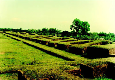

An isolated low, dimpled range of hills, dotted -with more than 50 ancient Buddhist settlements of the 8th to 12th century A.D. known as Mainamati-Laimai range are extended through the centre of the district of Comilla.

Salban Vihara, almost in the middle of the Mainamati-Lalmai hill range consists of 115 cells, built around a spacious courtyard with cruciform temple in the centre facing its only gateway complex to the north resembling that of the Paharpur Monastery.

Kotila Mura situated on a flaftened hillock, about 5 km north of Salban Vihara inside the Comilla Cantonment are is picturesque Buddhist establishment. Here three stupas are found side by side representing the Buddhist "Trinity" or three jewels i.e. the Buddha, Dharma and Sangha.

Charpatra Mura is an isolated small oblong shrinesituated about 2.5 krn. north-west of kotila Mura stupas. The only approach to the shrine is from the East through agateway which leads to a spacious hall.

The Mainamati site Museum has a rich and varied collection of copper plates, gold and silver coins and 86 bronze objects. Over 150 bronze statues havo been recovered mostly from the monastic cells, bronze stupas, stone sculptures and hundreds of terracotta plaques each measuring on an average of 9" higli and 8" to 12" wide. Mairiamati is only 114 km. from Dhaka City and is just a day's trip by road on way to Chittagong.

Moheshkhali


Moheshkhali is an island off the coast of Cox's Bazar. It has an area of 268 Sq. km. Through the centre of the island and along the eastern coastline rises a range of low hills, about 100 meters high.

In the coastal hills lies the old temple of Adinath, dedicated to Shiva, which becomes a place of pilgrimage during the month of Falgun (March). The western and northern coasts of the island form a low-lying tract that is fringed by mangrove forests. Tourists can reach this island by local motorboats called trawlers or by speedboat. By trawler, it takes an hour and a half and by speedboat only half an hour.

Tourists will find interesting sights like mangrove forests, hilly areas, salt fields etc. This island is famous for its Buddhist Temple or Pagoda; a whole day can be spent sightseeing if one includes visits to Sonadia and some other nearby islands.